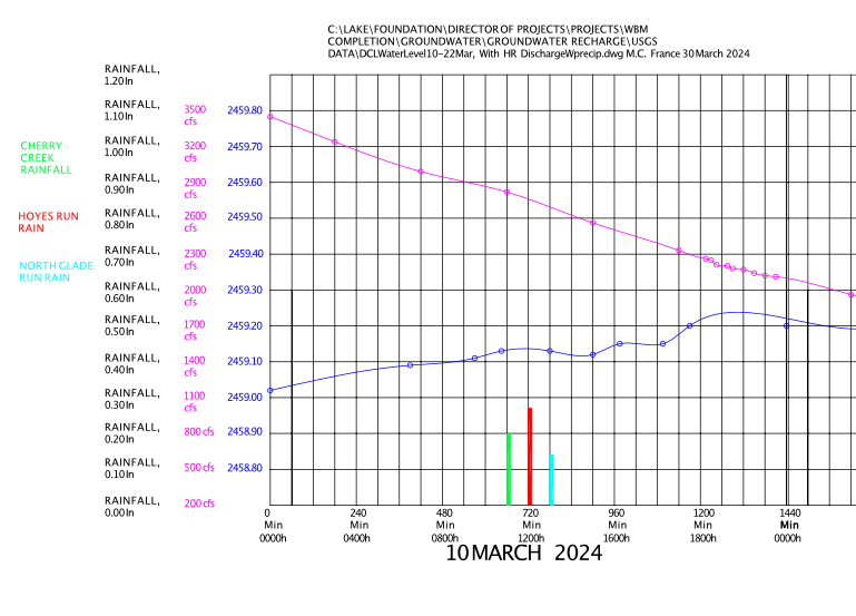
Deep Creek Watershed Foundation Recipient of Garrett County of the 2021 William Donald Schaefer Helping People Award
On Saturday morning, October 1, 2022, The Deep Creek Watershed Foundation (DCWF) will be honored as the recipient for Garrett County of the 2021 William Donald Schaefer Helping People Award. This award will be presented to the DCWF by the State of Maryland’s Comptroller, Peter Franchot. More information about this annual award and program can be found at the link below:
https://www.marylandtaxes.gov/divisions/comp/peter-franchot.php#wds
The DCWF is a 501 (c) 3 non-profit organization formed in 2016 and designed to accept tax deductible donations and use those donations over time to support the implementation of the Deep Creek Watershed Management Plan (WMP). The WMP was created in a collaborative effort between citizens of Garrett County, Garrett County Government, and the Maryland State Department of Natural Resources. It was clear to some of those citizens who assisted in the development of the plan, that neither the State nor County would alone be able to fund the myriad of projects necessary to implement the plan. To address this fiscal reality, the DCWF uses a methodology of creating public/private partnerships to fund projects DCWF and the projects if has supported thus far as well as planned for the future can be found on our Projects Page
The DCWF has an all-volunteer Board of Directors as well as a very supportive group of Advisors and Volunteers who assist the board in a wide variety of ways.
Financial support is received from individual donors, event sponsors, and grants, nearly, all of which, is applied to projects. Individuals wishing to donate may go donate via PayPal or forward checks to:
The Deep Creek Watershed Foundation
P.O. Box 376 Oakland, Maryland 21550
NRCS Agriculture Mapping
Create a Photo Map of Historic Shorelines From NRCS Agriculture Mapping
The time-rate of shoreline changes can be documented by rubber sheeting the photos onto a base map using features visible on the base map and on each sheet as it is brought in. Because of the spatial size of the project, it will need to be done digitally. From the file, the time rate of shoreline change can be documented and evaluated. The project partially fulfills Goal 3 of the Watershed Management Plan.
River Flow Gauge
River Flow Gauge on Youghiogheny River Above Deep Creek Nexus
Our next objective is to accrue donor funding of $21,750 in capital costs and a commitment of $17,970 for annual operation and maintenance for the gauge on the river upstream of where Deep Creek joins the Youghiogheny. The existing flows at that point subtracted from the flows measured at the Hoyes Run gauge will indicate the discharges from the Deep Creek watershed, including flows from the power plant and groundwater discharges.
The Completed Water Budget Model will be able to account for precipitation, groundwater recharge, flows through the power plant plus the discharges around the dam, factoring in the discharges required through the power plant by the Water Appropriation Permit. An apparently simple relationship determines the water levels in the lake: Water In – Water Out = Change In Water Level.
A recent bathymetric survey of Deep Creek Lake confirmed the Stage-Storage relationship determined when the lake was built by Youghiogheny Hydro-Electric Company. The project partially fulfills Goal 1 of the Watershed Management Plan.
Aquatic Invasive Species Legislation
Legislation is needed to address the lack of enforceable regulations regarding the launch and operation of boats that have been exposed to aquatic invasive species (AIS). The Policy Review Board* has formed a committee managed by Eric Null and Bob Browning. The Assistant States Attorney assigned to Deep Creek Lake has agreed to help craft the legislation. At this time the costs to the Foundation are unknown. The project partially fulfills Goal 3 of the Watershed Management Plan.
* The Policy Review Board (PRB) is a Maryland State Board which is charged with advising the Department of Natural Resources (DNR) on matters relating to lake fees, budget and management. In addition, the PRB and DNR were mandated to issue a Deep Creek Lake Recreation and Land Use Plan by June 2001 that provides for the wise use, protection and management of the natural and recreational resources of Deep Creek Lake. More information about the PRB can be found at the website for the Department of Natural Resources.
Precipitation Gauge Array Completion
Two new recording precipitation gauges will augment the USGS recording gauge at North Glade Run and afford reasonably good precipitation records. An analysis of the lake levels USGS measures on our behalf compared to the precipitation will show the relationship of groundwater recharge. The first gauge will be added to the stream flow measurement at Hoyes Run near the power plant. The second will be added to the gauge at Cherry Creek. The installation cost is $8,155 each, and the annual operation and maintenance cost is $4,575 each. The project partially fulfills Goal 12 of the Watershed Management Plan.
10-10 Shoreline Vegetation Project
The goal of the 10 in 10 Project is to reforest the buffer strip along the Lake shore with at least 10% of woody vegetation in 10 years using native trees shrubs and ground covers. A demonstration project in partnership with the Lake Management/DNR office at Deep Creek Lake State Park will be displayed along the 300 yard strip of waterfront to the right of the Launch Dock. This display will serve as a prototype. The purpose for a vegetated barrier is not just to prevent erosion but also to protect the water quality and shore and stream habitat.
Visitors to this site will find a meandering path and signage that identifies suggested landscaping plants all designed to enhance lake views while creating a healthy shoreline. Participation of property owners is voluntary. Other community partners include Property Owners Association (POA), various civic groups and Ashley Bechtel-Bodkins, one of our advisors and a Senior Agent at University of Maryland Extension Office in Garett County who will be involved with the planning.
DCWF does not have a cost estimate at this time. The 10 in 10 Project partially fulfills Goal 6 of the Watershed Management Plan. The Plan will be posted here upon completion.
Support for Dock Launch Stewards
In partnership with the Lake Manager and Garrett College, we purchased jackets and inspection equipment for the launch stewards stationed at the State Park Launch Ramp. We have committed $1,000 per year to support this effort. This project partially fulfills Goal 1 of the Watershed Management Plan.
Install and Maintain Water Levels & Temperature Gauges
The installation was completed in August 2020 at the cost of about $6,000, and an annual
maintenance cost of about $9,000 since then. The United States Geologic Survey has installed
and maintained the gauges and is paid for by the Foundation. The data from these gauges are
available on our website and on the USGS website. These projects are in partial fulfillment of
Goal 1 of the Watershed Management Plan.

Installation was completed in August of 2020 at a cost of about $6,000 and an annual
maintenance cost of about $9,000 agreed to. The gauges have been installed and maintained by
the United States Geologic Survey and paid for by the Foundation. The data from these gauges
are available on our website and on the USGS website. These projects are in partial fulfillment
of Goal 1 of the Watershed Management Plan.
The level gauge and the temperature component require regular calibration and maintenance.
The Foundation has committed to paying for the maintenance costs.
Eric Null, the Lake Manager, has noted the utility of continuous temperature monitoring for our
Eutrophic lake: “There are three basic types of lakes, Dystrophic, Eutrophic, and Oligotrophic.
Dystrophic lakes have no oxygen, while Eutrophic lakes have their greatest amounts of oxygen
at the surface. Oxygen then decreases as you increase depth. Oligotrophic Lakes have evenly
distributed oxygen. Oligotrophic lakes do not turn over seasonally, therefore, have a very low
nutrient concentration (infertile). Eutrophic lakes turnover seasonally due to their stratification
of oxygen, temperature, and nutrients.
This turnover is essential for life in a Eutrophic lake. Every spring as the temperature rises and
warms the water’s surface to the temperature of the bottom of the lake (lakes can stay 40+
degrees on the bottom during winter), the wind mixes the surface with the deeper water, the
wind continues to mix the water until the top layer of water slides beneath the bottom layer. The
bottom becomes the top and brings all of the nutrients that fell to the bottom (dead organic
matter) to the surface of the lake where they can be processed by biological organisms. In fall,
the same event happens in reverse. As the surface water cools, it becomes denser and pushes the
warmer bottom water to the surface with all of the summer nutrients. These events cause cloudy
water that can be tinted green. The cloudiness is nutrients and the green are phytoplankton, the
beginning of the lake’s food chain.
These nutrients fuel life in the lake through the winter and the summer. Without the natural
turnover phenomenon, a Eutrophic or Mesotrophic (a high-quality eutrophic lake) lake could not
sustain life. Temperature is vital for fishing, especially during turnover. During turnover, the
surface’s temperature, nutrient, and oxygen concentration change dramatically for a week or two,
forcing fish to the bottom of a lake and suppressing their appetites. Also, temperature dictates
where certain fish species will be feeding in a lake. Temperature stratification of a lake in
summer is the key factor to fishing success.
Water Wise Program – Rain Barrels
This program is consistent with Deep Creek Watershed Plan Goal 6: Prevent erosion and sedimentation to the greatest extent possible to protect water resources from increased sediment loading and associated water quality problems, and its Objective 3: Revise, streamline, and incentivize lake shoreline protection measures and permitting.
According to the Plan: The primary sources of sediment in the watershed, in no particular order, are:
- Stormwater runoff from cultivated farmland
- Stormwater runoff from developed land
- Stormwater runoff from forested land
- Stream bank erosion
- Lake shoreline erosion from wind and boat wakes.”
The Watershed (Plan) Administrator and staff in the University of Maryland’s Extension services have examined and prioritized this issue as a significant and reachable goal/objective. Indeed, the University of MD Extension service has been running programs and is already maintaining a website regarding homeowner stormwater practices. In addition, the Extension service has on its staff a great team of watershed specialists who have led and will continue to lead educational programs about
stormwater management.
We, along with the Garrett College’s Continuing Education & Workforce Department, and the Garrett County Government, sponsor the University of Maryland Extension Service’s public presentations on managing stormwater runoff. The problem is especially severe when rainwater runs over hard surfaces, such as driveways and rooftops, picking up sediment, chemicals, debris and toxins that are carried into local streams.
The Extension Service’s presentations cover the use of rain barrels and cisterns, rain gardens, conservation landscaping and riparian buffer planting, among other ways to ameliorate runoff and prevent erosion. These sessions are presented by Ashley Bodkins, who also is an advisor to the Deep Creek Watershed Foundation.
Contact information: Ashley is also coordinating the University of Maryland Master Gardner program on behalf of the Foundation.
This project partially fulfills Goal 6 of the Watershed Management Plan.